
Sea and air rescue: understanding Cospas-Sarsat
In Search and Rescue, distinguishing between aeronautical SAR and maritime SAR is useful from an operational standpoint, because it means recognising different contexts, each with its own procedures, assets, skills and specific constraints. The rescue of a missing aircraft is not organised in the same way as that of a vessel in difficulty, and every scenario calls for tools and decisions consistent with the environment in which the operation takes place.
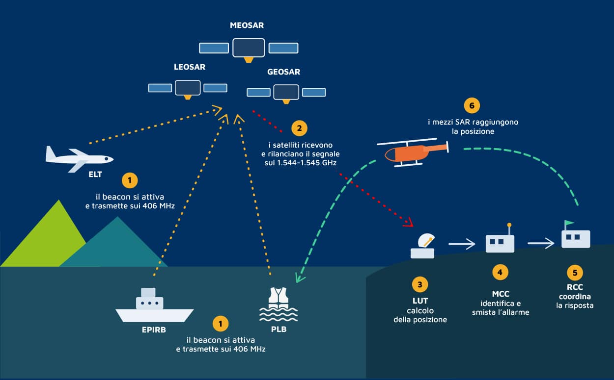
However, this distinction risks being misleading on a conceptual level if it suggests the idea of two separate worlds. In reality, the core of SAR remains the same: triggering the alert quickly, obtaining a reliable location, sharing useful data and coordinating an effective response. It is precisely this common foundation that makes it clear how aeronautical and maritime SAR should be read as two applications of a single rescue system.
From aeronautical SAR to maritime SAR: a unified rescue system
The point at which this convergence becomes most evident is the Cospas-Sarsat system, the international satellite network that receives, identifies and routes emergency alerts transmitted on 406 MHz. This is where the continuity between sky and sea takes concrete form: an ELT installed on board an aircraft, an EPIRB carried on a vessel or a PLB used for personal use address different needs, yet belong to the same rescue architecture. The operational context, the placement of the device and the regulatory requirements change; what does not change is the purpose of the system, namely to generate a reliable, identifiable and locatable signal, capable of rapidly reaching the rescue coordination centres.
MEOSAR and Cospas-Sarsat: how technology improves localization and response times
It is the MEOSAR segment that today represents the most significant evolution of this architecture. Unlike low-orbit satellites, which pass over a given point only at intervals and reconstruct the position by exploiting the Doppler effect across several passes, the MEOSAR repeaters are hosted on the major navigation constellations — GPS, Galileo, GLONASS and BeiDou — and operate in medium Earth orbit, at altitudes between 19,000 and 24,000 kilometres. From that height, each satellite “illuminates” roughly one third of the globe and, with dozens of platforms constantly active, the system ensures that several satellites are always in view simultaneously from any point on Earth. Every distress signal is therefore received and relayed at the same instant by several satellites towards several ground stations, known as MEOLUTs, which process it in parallel. This is a change of scale that translates into four very concrete advantages for those who operate in the rescue field.
The first is continuous global coverage: there are no longer any blind spots or delays linked to a satellite pass, because the signal is picked up and retransmitted in real time, without the store-and-forward logic typical of low-orbit systems. The second is the near-instantaneous alerting: whereas the older LEOSAR could take up to two hours to consolidate an alert, MEOSAR makes detection virtually immediate, because the same signal is intercepted simultaneously by several satellites and several antennas. The third is high-accuracy location: MEOLUT stations calculate the position independently by cross-referencing the time and frequency of arrival of the signal across several satellites — a triangulation conceptually similar to GNSS — which drastically narrows the search area and remains valid even when the position data encoded in the beacon is missing or unreliable. The fourth, made possible in particular by the Galileo component, is the Return Link Service (RLS): a return channel that sends the device in distress a confirmation that the alert has been received and located, typically through an indicator light or a message on the display. It does not mean that rescue units have already been dispatched, but it gives those in distress a valuable piece of information, both operationally and psychologically: the signal has gone out and has reached its destination.
This continuity is what makes it increasingly less useful to think in rigid compartments. In aeronautical SAR, the speed of a correct alert can make the difference in locating a missing aircraft, a crew forced to ditch, or an asset engaged in offshore operations. In maritime SAR, the same principle applies to scenarios in which distance from the coast, exposure to weather conditions, wave motion and survival times demand an extremely precise response. In both cases, everything starts with the quality of the first available data.
This is why location is not an accessory element, but the first link in the decision-making chain. If the signal is accurate, if the device is correctly configured and if the transmitted information is immediately usable, the entire system responds better. Margins of uncertainty are reduced, the search area is narrowed, the deployment of assets is optimised and the probability of mission success increases. Conversely, incomplete or unreliable data slows down every subsequent phase and can compromise the effectiveness of the operation. And the first useful data is generated even before the emergency: a correctly coded and properly registered beacon allows the centres to associate the signal with a specific asset and a point of contact, turning a few bits of data into an immediate operational identity.
It is also for this reason that value today lies not only in the beacon, but in the entire technical ecosystem that makes it truly effective. Programming, configuration, maintenance, certification, environmental robustness and proper integration with operational procedures and platforms are all decisive factors. On the one hand, the aviation sector brings with it a well-established culture of certification, management of critical equipment and configuration accuracy. On the other, the maritime sector contributes essential experience in resistance to immersion, salt, impact, capsize and long periods of inactivity. It is in the convergence of these fields of expertise that a more advanced vision of rescue takes shape.
From this perspective, SAR is no longer merely the sum of specialist technologies, but an integrated operational capability that must work seamlessly across different environments. And it is precisely on this ground that the Cospas-Sarsat system today represents one of the strongest points of connection between the aviation and maritime worlds: a single infrastructure, a single emerge
Avioconsulting: the go-to partner for SAR in Italy
Against this backdrop, Avioconsulting supports companies, operators and organisations working in Search and Rescue with technical and commercial support focused on real-world reliability. From consultancy on the positioning of certified solutions to the programming and reprogramming of equipment, through logistics and spare parts management, the aim is to turn technology into real operational capability. Because when every second counts, having a device is not enough: what is needed is a system that is ready to perform, from sky to sea, without uncertainty.